Saturday, April 28, 2012

Road trippin'

Since it has been a good while since my last article, I suppose it would be good to post something new so that the world knows that I have not died somewhere in the woods.
See, still alive.

 After a week long visit to friends at Southern Adventist University, I decided that the winter weather was quickly approaching so the original route of the trail of tears water route was probably no longer a viable option for two reasons. First being that it goes north west which would have taken me into the colder weather rather than away from it, and second reason being that I would be over the water during snow and cold rain. This probably would not have been a good situation for me. So I decided to reroute straight south and shoot for the gulf coast. I had never been to the gulf before so it would be a treat for me any way. The problem with this route is that there are no established trails, which means a lot of road walking. On my way through Georgia I was stopped by police twice for no reason and taken to the edge of their jurisdiction and told not to return. For the most part the route I took through Georgia was hot, flat, and boring. However, I noted on the map that there was a state park called Kolomoki mounds. Curious as to what it was, I decided to make that my goal for this state. After several days of walking and worrying that I would get picked up again just before arriving there, I finally made it to the park. Kolomoki is an interesting burial mounds park. It has several mounds on the property, including a massive temple mounds. The best of these mounds can be found inside the visitor center which was built over top of it. The mound belonged to a Chieftain and has been excavated and a board walk going around it for visitors to get a close look.
If you are in the Area, I would definitely advise you to stop by and take the tour, which costs a whopping three bucks. The museum inside the visitor center has a large collection of artifacts from the grounds including earthen pottery and statues. Unfortunately, the collection used to be bigger, but the place was robbed and a lot of the collection has been lost as a result.

After leaving Kolomoki I resumed my shot towards Florida. I started to notice the landscape and climate changes that were taking place around me as I went ever south. The changes started in the northern part of the state and became increasingly noticeable as I went further. It started with simple things like saw palmettos and hanging mosses and then came my very first live Armadillo sighting, and scorpions showing up at night.
Needless to say I was slightly more worried about finding the scorpions coming into my camp at night than I was the armadillos, though the dillos payed me several visits each night. Eventually I made it into Florida and saw the Gulf coast for the first time.

Wednesday, October 26, 2011

The Appalachian Trail

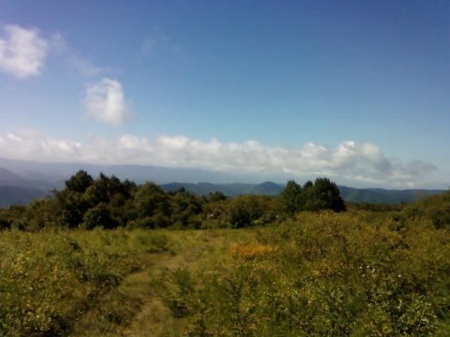
I know it has been a long time coming but in my defense a good library is harder to find then one might think in this modern times.  So with out further delay I would like to discuss the AT and all it's glory. I started out in Pearisburg Va. I was definitely shocked at how hard the first climb was. I ended up climbing up to around 3000 feet in the span of a mile and a half to two miles. At the top I was greated by a wonderful scenic spot called angel's rest.
From there I went on to see my first eight bears of the trail. They were all hanging around the area of the rest because there was a spring, blueberries, nut trees and several large bee hives in the area and there was little to no water else where. Some of the younger bears were inquisitive and one started to run up to me to check me out. I decided it was best to yell at it to run it off. Some people may be feeding these things like they do in the great smokey mountains. More on that later. I ended up walking another eight miles to the first shelter of the AT that I stayed in. Doc's Knob
These shelters are pretty nice though they tend to be over run with mice and sometimes even bats. The problem with Doc's Knob was that the nearby spring was dry. I ended up walking eight miles in high heat the next day before finding a blue blaze trail, which usually means water. Turns out it was just another trail that some idiot decided to mark with blue blazes. I walked it for around a mile before coming out on a dirt road with tire and horse tracks. Since I was feeling sick from heat and no water I decided to follow it down hill hoping it would lead to a stream or a town. Eventually a conservation officer drove up the road and gave me a lift to a gas station where I slammed a quart bottle of gateraid and bought two one liter bottles of water and a country time lemonaid. I got back onto the trail refreshed and ready to go. Only to find out that by getting off the trail I missed the next shelter and ended up walking another eight miles to jenny's knob shelter. So in my second day I made out with eighteen miles progress down the trail.
My first few weeks on the AT were definitely slow going since it is harder than the rail trails I had just come off of. The thing about the AT is that if it can go uphill, it will. The highest point I got to was at spruce knob which sits at 4429 feet. There is a really nice shelter there, but the nearby spring was bone dry. I attempted to dig a hole to fill with ground water but when I tried pumping it my water filter cartridge ruptured and spat out dirty water.
The place has a really nice view though. and even ginseng in the nearby areas.
So aside from having to boil water there was no problems in the past few weeks of travel. I stayed at spruce knob for two days. After that I decided it would be best to get off the trail and road walk to damascus VA where I could get a new filter. This way I could stop at stores for water when I needed it. I ended up stoping at three Mcdonalds a subway and some kind of stand called dipdogs, which makes an awesome banana milkshake, by the way. With all that super healthy food in my veins I had enough energy to walk thirty miles a day and made it to Damascus in only two days. I went to Sundog's outfitters for my new katadyn mini ceramic filter which was on sale 50% off since I'm walking after season. I stayed at the local church hostel and met a kid named Josh who I walked with for a good while before getting off the trail in TN.

Along the trail I was able to collect hickory nuts, butter nuts, walnuts and various other wild foods to save on money and add nutrition to my diet. Because all of these nuts were in the area it is also a good spot to see bears. These ones all seem to have a healthy fear of man so it's okay to walk quietly in hopes of seeing a few. If you are walking in the fall like I am try looking in the tree tops for them as they like to go up and eat the nuts up there. Do not worry though. No matter how quiet you are they will still notice you before you notice them in most cases and you will see them as they are coming down the trees to run away. I lost count at around 70 bears, most of which were on iron mountain.

As we progressed further south we started to meet northbounders that told us that the shelters in the smokeys were closed and you are not allowed to camp just any where. This was due to idiots feeding the bears which resulted in several people being stalked by them and even a few attacks. Do not be one of those idiots. You ruin it for every one else by feeding these animals. I decided to get off the trail in Hampton TN since the smokeys were basically closed. As a result I missied out on clingman's dome and several other big mountains. I did however stay at kincora hostel.


The one bad thing about this place is if you have cat allergies, you are going to feel it. They have several cats there. They do have a tree house out back but it only has one bed. The night I stayed there I got to meet the racoons that live under the cabin and come up at night to finish off the cat food left behind.


Some tips I would give for the trail and long distance hiking in general. Be inventive. There will be times when something will break or wear out and replacing it can become expensive. If you repair it with what ever else you might have around you save money and lots of it.
The snap on my knife sheath rusted and the button pulled free of the fabric so I used a buckle from the side of my army pants and a little bit of strapping cut to fit and made this little set up.
You can also make things from trash other idiots leave behind like this little hobo stove I made from a sterno can.

  It is very easy to make and does a good job of cooking food pretty quickly.

There are tons of wildlife along the trail provided people do not run it all off with stupid bells and whistles. Some of the easier ones to catch sight of are the slow moving small ones.


Since getting off the trail I have made my way south west to collegedale and stopped for a three week break along the way at Cherokee lake. I will discuss that and the adventures along the way in my next blog post.

Tuesday, August 30, 2011

Just what the heck is the allegheny trail?

That seems to be the question I'm faced with anytime I ask a local where to get onto it at, even if they have a yellow marker right in front of their storefront. It just seems that the Allegheny is not maintained, hardly marked and not well known at all. I started my trip on the Allegheny but ended up road walking and taking a few other trails to get south. In fact there was a time when the Allegheny just stopped on me in the middle of the woods and I was just left standing there thinking "Crap where do I go now?" Luckily I knew another trail was a few miles west of me so I hacked my way through rhododendrons and stumbled down treacherous mountains to finally reach it at one in the morning. The good trails I have been on so far would be the North Fork rail trail which runs 26 miles from Glady, WV to Durban WV. This trail is well maintained but during the week it is hardly used. In fact I did not see a single person on it the whole two days I was there. It passes through some pretty remote areas full of animals, wild fruits such as apples, blackberries, and elderberries.
 Watch out though because I walked up on a bear in the middle of a blackberry patch. The other trail I took was the Greenbriar river trail. This trail runs 79 miles from Cass, WV to Caldwell, WV. It to is a rail trail with a very easy one percent grade the whole way. You will see bears, deer, osprey, woodpeckers, and many more animals. One of the signs along the way claims that there are even bald eagles there, but I was not fortunate enough to see one. This trail offers two tunnels and a multitude of bridges. There are plenty of great swimming and fishing holes where you can catch small mouth bass, native brook trout and other good game fish.


From this trail I walked to Pearisburg, VA to join up with the Appalachian trail and that is where I stand now on this journey. I am currently resting at the Holy Family Church Hostel, which is run by the Catholic church here in Pearisburg for hikers and backpackers of the AT. It is a free Hostel, but they do accept donations in order to keep the Hostel running. I will be uploading pics as soon as I find a place which I can pop my SD card into.

For extra cash I have been keeping my eye out for some things I have discussed in previous posts, such as ginsing. I have so far found a few nice peices and a couple of smaller pieces which I sometimes use in tea made from sassifrass.
                                                       A nice piece I found along the trail.


Ginsing is predicted to hit 1000 dollars per dried pound this year so lets hope I find lots more like this one.
If you would like to see all of my trip pics so far feel free to add me on facebook at Franklin Radcliff.

Thursday, August 11, 2011

The Big Trip


I know I posted about this idea earlier, but after some planing I have the approximate route I want to take. This will be a grueling trek across the country in some of the most extreame environments and remote areas. I will start out on the allegheny trail and head east to the Appalachian trail. From there I plan to head south as far as chattanooga TN, and jump onto the trail of tears. This leg of the journey will cover a tragic trail taken by the Cherokee nation after their defeat by the US government. After some time I plan to go off trail towards Jefferson city and jump onto the Santa Fe National Historic trail. This leg covers the route settlers took to Santa Fe. After that I will jump onto the Continental divide trail for the first time. I will head south nearly to the border then road walk to the Juan Bautista De Anza National Historical trail. After som time I will get onto the Pacific Crest scenic trail and head all the way up to crater lake and other scenic areas in the north. I will follow the footsteps of lewis and clark until I hit the Continetal divide trail for the second time. This time I will follow it north to the Glacial national park. After some time exploring around there I will then follow the trail back south hitting most major national parks on or near the trail. This will include the grand canyon, mesa verde and many more unique and interesting sites. After that I will get back onto the Santa Fe historic trail until I reach another section of the Lewis and Clark trail and follow it back up north to the North country Scenic trail. I will then follow that back to West Virginia.

Along the way I expect to face many challenges and hazards. I will meet new people and get in touch with nature. Most importantly I will find out if i have what it takes to backpack America...

Friday, July 22, 2011

A long Journey

So a lot has been going on since my last post a few months ago. In my infinite wisdom, I had quit my job in order to move back to West Virginia to help some one who was in need. As it turns out she had lied to me in order to use me for food, shelter and money. So now I'm stuck in WV with no money and bouncing from job to job looking for something better. So I've been volunteering at a christian camp. It was here that I have decided to take a trip. This trip will be a long and dangerous road. My plan is to take the Appalachian trail south, then go west as far as California then back north east to the continental divide trail and up north as far as glacial national park and from there back east to West Virginia. The trip will probably take around two years and around 9-10,000 miles. I'll be stopping at several of the biggest national parks along the way as well as doing as much treasure hunting for extra cash as I can. I hope to stop off and update this blog with pics and such along the way. Wish me luck guys.